![](/images/other/stat-length.png)
![Tocht Stappen Vire Normandie - Rando « Granit Eau Bois 2012 » - Photo](https://media.geolcdn.com/t/1900/400/ext.pjpeg?maxdim=2&url=https%3A%2F%2Fservices.sitytrail.com%2FGeolivesWS%2FDownloadMedia.ashx%3FTrailID%3D173165%26Media%3D14740_6.jpg)
Rando « Granit Eau Bois 2012 »
tracegps
Gebruiker
![Lengte](/images/other/stat-length.png)
Lengte
43 km
![Max. hoogte](https://static1.geolcdn.com/siteimages/upload/files/1508320355ic_sort_altitude_max_24dp.png)
Max. hoogte
348 m
![Positief hoogteverschil](https://static1.geolcdn.com/siteimages/upload/files/1508320355ic_sort_den_pos_24dp.png)
Positief hoogteverschil
778 m
![Km-Effort](/images/other/stat-length.png)
Km-Effort
53 km
![Min. hoogte](https://static1.geolcdn.com/siteimages/upload/files/1508320355ic_sort_altitude_min_24dp.png)
Min. hoogte
108 m
![Negatief hoogteverschil](https://static1.geolcdn.com/siteimages/upload/files/1508320355ic_sort_den_neg_24dp.png)
Negatief hoogteverschil
695 m
![Boucle](https://static1.geolcdn.com/siteimages/upload/files/16400158638029165_repeat_loop_refresh_sync_direction_icon.png)
Boucle
Neen
Datum van aanmaak :
2014-12-10 00:00:00.0
Laatste wijziging :
2014-12-10 00:00:00.0
![Stappen](https://static1.geolcdn.com/sitytour/trail-icons/101.png)
7h30
Moeilijkheid : Zeer moeilijk
![Scan deze QR-code om de tocht te openen in de SityTrail-applicatie](https://capi.geolives.com/qq0zvz2zws4bq2lad0pu/sitytour/trails/173165/qr.png?size=200)
Gratisgps-wandelapplicatie
Over ons
Tocht Stappen van 43 km beschikbaar op Normandië, Calvados, Vire Normandie. Deze tocht wordt voorgesteld door tracegps.
Beschrijving
Une randonnée début octobre. Je vous conseille vivement cette belle manifestation, en un mot PARFAIT A FAIRE ET REFAIRE. Visitez le site GRANIT EAU BOIS.
Plaatsbepaling
Land:
France
Regio :
Normandië
Departement/Provincie :
Calvados
Gemeente :
Vire Normandie
Locatie:
Vire
Vertrek:(Dec)
Vertrek:(UTM)
654984 ; 5412578 (30U) N.
Opmerkingen
Wandeltochten in de omgeving
![Tocht Mountainbike Vire Normandie - Rando VTT de Roullours - 2010 - Photo](https://media.geolcdn.com/t/375/260/ext.jpg?maxdim=2&url=https%3A%2F%2Fstatic1.geolcdn.com%2Fsiteimages%2Fupload%2Ffiles%2F1524743154velo.jpg)
![Mountainbike Mountainbike](https://static1.geolcdn.com/sitytour/trail-icons/202.png)
Rando VTT de Roullours - 2010
Mountainbike
Medium
(2)
Vire Normandie,
Normandië,
Calvados,
France
![](/images/other/stat-length.png)
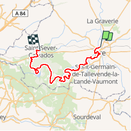
36 km | 44 km-effort
2h 15min
![](https://static1.geolcdn.com/siteimages/upload/files/16400158638029165_repeat_loop_refresh_sync_direction_icon.png)
Ja
![Tocht Te voet Vire Normandie - Le Moulin de Roullours - Photo](https://media.geolcdn.com/t/375/260/c6e30a1d-183d-4bbf-b491-5bc7356ba6c6.jpeg&format=jpg&maxdim=2)
![Te voet Te voet](https://static1.geolcdn.com/sitytour/trail-icons/100.png)
Le Moulin de Roullours
Te voet
Gemakkelijk
Vire Normandie,
Normandië,
Calvados,
France
![](/images/other/stat-length.png)
6 km | 7 km-effort
1h 35min
![](https://static1.geolcdn.com/siteimages/upload/files/16400158638029165_repeat_loop_refresh_sync_direction_icon.png)
Ja
![Tocht Te voet Vire Normandie - Le Domen de la Loge aux Sarrasins - Photo](https://media.geolcdn.com/t/375/260/3400dd42-5454-40aa-a557-238e8435f2ee.jpeg&format=jpg&maxdim=2)
![Te voet Te voet](https://static1.geolcdn.com/sitytour/trail-icons/100.png)
Le Domen de la Loge aux Sarrasins
Te voet
Gemakkelijk
Vire Normandie,
Normandië,
Calvados,
France
![](/images/other/stat-length.png)
14,1 km | 16,6 km-effort
3h 46min
![](https://static1.geolcdn.com/siteimages/upload/files/16400158638029165_repeat_loop_refresh_sync_direction_icon.png)
Ja
![Tocht Te voet Vire Normandie - Le Bois de l'Ermitage - Photo](https://media.geolcdn.com/t/375/260/a9e6a9f5-b157-416b-8873-53a121881116.jpeg&format=jpg&maxdim=2)
![Te voet Te voet](https://static1.geolcdn.com/sitytour/trail-icons/100.png)
Le Bois de l'Ermitage
Te voet
Gemakkelijk
Vire Normandie,
Normandië,
Calvados,
France
![](/images/other/stat-length.png)
3,1 km | 3,9 km-effort
53min
![](https://static1.geolcdn.com/siteimages/upload/files/16400158638029165_repeat_loop_refresh_sync_direction_icon.png)
Neen
![Tocht Auto Vire Normandie - Hakan - Photo](https://media.geolcdn.com/t/375/260/ext.jpg?maxdim=2&url=https%3A%2F%2Fstatic1.geolcdn.com%2Fsiteimages%2Fupload%2Ffiles%2F15247431544x4.jpg)
![Auto Auto](https://static1.geolcdn.com/sitytour/trail-icons/401.png)
![Tocht Stappen Vire Normandie - centre ville de Vire - Photo](https://media.geolcdn.com/t/375/260/ext.jpg?maxdim=2&url=https%3A%2F%2Fstatic1.geolcdn.com%2Fsiteimages%2Fupload%2Ffiles%2F1553511878bg_sport_marche.png)
![Stappen Stappen](https://static1.geolcdn.com/sitytour/trail-icons/101.png)
centre ville de Vire
Stappen
Medium
Vire Normandie,
Normandië,
Calvados,
France
![](/images/other/stat-length.png)
5,7 km | 7,9 km-effort
1h 47min
![](https://static1.geolcdn.com/siteimages/upload/files/16400158638029165_repeat_loop_refresh_sync_direction_icon.png)
Ja
![Tocht Fietstoerisme Vire Normandie - Activity - Photo](https://media.geolcdn.com/t/375/260/ext.jpg?maxdim=2&url=https%3A%2F%2Fstatic1.geolcdn.com%2Fsiteimages%2Fupload%2Ffiles%2F1524743154velo.jpg)
![Fietstoerisme Fietstoerisme](https://static1.geolcdn.com/sitytour/trail-icons/204.png)
Activity
Fietstoerisme
Medium
Vire Normandie,
Normandië,
Calvados,
France
![](/images/other/stat-length.png)
24 km | 28 km-effort
Onbekend
![](https://static1.geolcdn.com/siteimages/upload/files/16400158638029165_repeat_loop_refresh_sync_direction_icon.png)
Neen
![Tocht Andere activiteiten Vire Normandie - Basse Normandie - Ligne 440 - Vire - Romagny - Photo](https://media.geolcdn.com/t/375/260/ext.jpg?maxdim=2&url=https%3A%2F%2Fstatic1.geolcdn.com%2Fsiteimages%2Fupload%2Ffiles%2F1545311037marcheuse_200dpi.jpg)
![Andere activiteiten Andere activiteiten](https://static1.geolcdn.com/sitytour/trail-icons/900.png)
Basse Normandie - Ligne 440 - Vire - Romagny
Andere activiteiten
Heel gemakkelijk
Vire Normandie,
Normandië,
Calvados,
France
![](/images/other/stat-length.png)
39 km | 45 km-effort
5min
![](https://static1.geolcdn.com/siteimages/upload/files/16400158638029165_repeat_loop_refresh_sync_direction_icon.png)
Neen
![Tocht Fiets Vire Normandie - 2016-Vélofrancette n° 11 - Photo](https://media.geolcdn.com/t/375/260/ext.jpg?maxdim=2&url=https%3A%2F%2Fstatic1.geolcdn.com%2Fsiteimages%2Fupload%2Ffiles%2F1524743154velo.jpg)
![Fiets Fiets](https://static1.geolcdn.com/sitytour/trail-icons/200.png)
2016-Vélofrancette n° 11
Fiets
Medium
Vire Normandie,
Normandië,
Calvados,
France
![](/images/other/stat-length.png)
36 km | 42 km-effort
2h 24min
![](https://static1.geolcdn.com/siteimages/upload/files/16400158638029165_repeat_loop_refresh_sync_direction_icon.png)
Neen